The Ancient World Mapping Center
AWMC and Pelagios
The Ancient World Mapping Center is happy to formally join the Pelagios network. AWMC and Pelagios share a commitment to the curation of authoritative and uniform ancient world geographic information online and to the construction of networks (both human and virtual) to link together data in the best possible way. Below we offer some background on AWMC and its remit, along with some overview information about the center’s database, Antiquity À-la-carte 2.0 (a mapping application), and a recently launched API. Jeffrey Becker currently directs the AWMC; Ryan Horne is the chief engineer of Antiquity À-la-carte 2.0, the AWMC API, and the Center’s web and data architecture.
The Ancient World Mapping Center at UNC-Chapel Hill
When the Barrington Atlas of the Greek and Roman World (R. J. A. Talbert ed., 2000) appeared in 2000 it represented both a milestone in and a landmark for ancient world geography, as it not only was the first comprehensive ancient world atlas since Smith and Grove (1872) but also it created an enormous amount of metadata related to the atlas’ 102 maps. The metadata was initially contained in the Map-by-Map Directory and on CD-ROM, but soon formed the nucleus of the Pleiades Project, under the direction of Tom Elliott, who also served as the founding director of AWMC. The Classical Atlas Project, thus, spawned the atlas itself as well as a research center that has been engaged in carrying forward the work of the atlas project for more than a decade. The Ancient World Mapping Center, based at the University of North Carolina at Chapel Hill in the United States, endeavors, with its partners, to constantly refine and expand the geo-database created initially by the Barrington Atlas. In addition to data curation and refinement, AWMC actively promotes ancient world geography and its study, along with the application of Geographic Information Systems (GIS) for the study of the ancient world. AWMC’s own research projects, including material to accompany Richard Talbert’s Rome’s World: The Peutinger Map Reconsidered (Cambridge 2010), advance research agendas that seek to expand our knowledge of ancient geography and worldview. Benthos, a new initiative, seeks to create a digital atlas of ancient waters, including information for ancient shipping, shipwrecks, and trade routes. Educational outreach, by way of a series of wall maps, as well as digital platforms, aims not only to share geographic information with both professional and avocational constituencies, but also to demonstrate the extremely fruitful intersection of ancient world geography and the latest in technology. AWMC believes strongly in the potential of linked data for the ancient world and thus feels that the networking provided by both Pleiades and Pelagios offers important opportunities for interoperability and cooperation in the digital sphere.
Antiquity À-la-carte 2.0
Antiquity À-la-carte 2.0 is a web-based GIS application that allows users to create custom maps using data extracted from AWMC's database. This application is flexible and easily customizable based on the individual needs of the user. In conceptualizing the application, a point of departure was the traditional static paper map made for classroom use which, while informative, is limited in its range of uses. Antiquity À-la-carte 2.0, on the other hand, provides nearly limitless functionality in that not only can a map be created for a specific need, but the user is enabled even to add custom geographic content and cultural/historical information to the map.
AWMC API
The AWMC API allows users to interact directly with the geo-database maintained by AWMC. The API provides access not only to the entire Pleiades data set (including geographic information for all content derived from the Barrington Atlas along with various sets of metadata), but also to polyline information for the physical geography of the ancient Mediterranean and Near Eastern worlds. This latter set includes coastlines, water features (both open and inland), line work (roads, aqueducts, bridges), cultural shading (e.g. Roman city footprints), and terrain. All of this data is released to the user under the terms of the Creative Commons License for non-profit educational and scholarly use.
Linking to Pleiades / Pelagios
The AWMC has long used geographic software for the creation of maps, initially by creating geographic layers with ESRI ArcGIS and adding cultural data from pre-existing maps and the Pleiades Project, then refining the result through Adobe Illustrator. The Antiquity À-la-carte initiative was born out of the recognition that a much more robust system was needed to retain, modify, and display our extensive data and to align our work with other digital initiatives. Our initial steps were to create a PostGIS database using the Pleiades .csv files, with a point geometry object created out of the representative longitude and latitude for each feature. Next, we created a simple PHP script to update our database from the Pleiades daily data dumps, excluding any changes that we make to an object’s geometry (which we represent by a Boolean flag in our database). We then made a script to automatically generate a .wms file of these features, which allow us to query them in ArcGIS and to instantly align any of our map commissions or projects with correct Pleiades IDs and to quickly identify any individual features that need to be moved or modified, which we then feed back into Pleiades. In addition, we placed all of our geographical and cultural information (roads, rivers, inland water, aqueducts, islands, urban areas, additional or alternate names, etc.) into the database, which resulted in over 200,000 (and counting!) entries.
The culmination of this work can be seen in the Antiquity À-la-carte application, built upon MapServer, OpenLayers, and GeoExt. Using the 3 arc second SRTM data from NASA for our base (void filled with lower resolution SRTM data), we modified the elevation raster data to conform to our ancient coastline (which, along with other geographical features, are heavily modified shapefiles from Vmap0). We also created many shapefiles from scratch, such as roads, aqueducts, and cultural information, all of which follow the Barrington Atlas and conform to the modified SRTM background. We then added the .wms file of all the Pleiades data (essential due to feature number limitations in OpenLayers) and integrated our PostGIS database of Pleiades entries to allow a user to search for a particular feature by its name, Pleiades ID number, geographical location, or other information.
The resulting map is fully customizable, with the ability to add any Pleiades feature, sort by time periods, modify names, locations, labels, and feature types to any user specifications. A user created map can be exported as a .pdf, a .kml file, a .csv list with GeoJson geometries, or as a GeoJson object that can be directly used by OpenLayers or imported back into À-la-carte. A map can also be easily linked to in a variety of ways through URL parameters as detailed here. This linking relies on json notation, and can be used to specify feature names, Pleiades IDs, and even zoom levels and map centering. This can serve as an efficient means to display an accurate ancient geographical map for projects or initiatives that have Pelagios / Pleiades aligned data who do not want to create their own maps or are restricted from running javascript applications of their own. An example URL, in this case representing some features around Pergamum, looks like the following:
http://awmc.unc.edu/awmc/applications/alacarte/?jsonGet={“zoom”:”6″,”center”:”lon=26.865381755052,lat=38.848414981353″,”pids”: [{"pid": "550812"},{"pid": "599612"},{"pid": "550893"},{"pid": "550908"},{"pid": "222192"},{"pid": "507469"},{"pid": "550898"},{"pid": "599947"},{"pid": "897849"},{"pid": "550595"},{"pid": "550696"},{"pid": "550497"}]}
Since each feature in our database already has a Pleiades ID, it was a simple matter to integrate a particular place on our map directly into the Pelagios network. For instance, if Alexandria in Egypt is clicked on the map a popup is generated which allows the user to directly access and browse the Pelagios API via a link created in a PHP script.
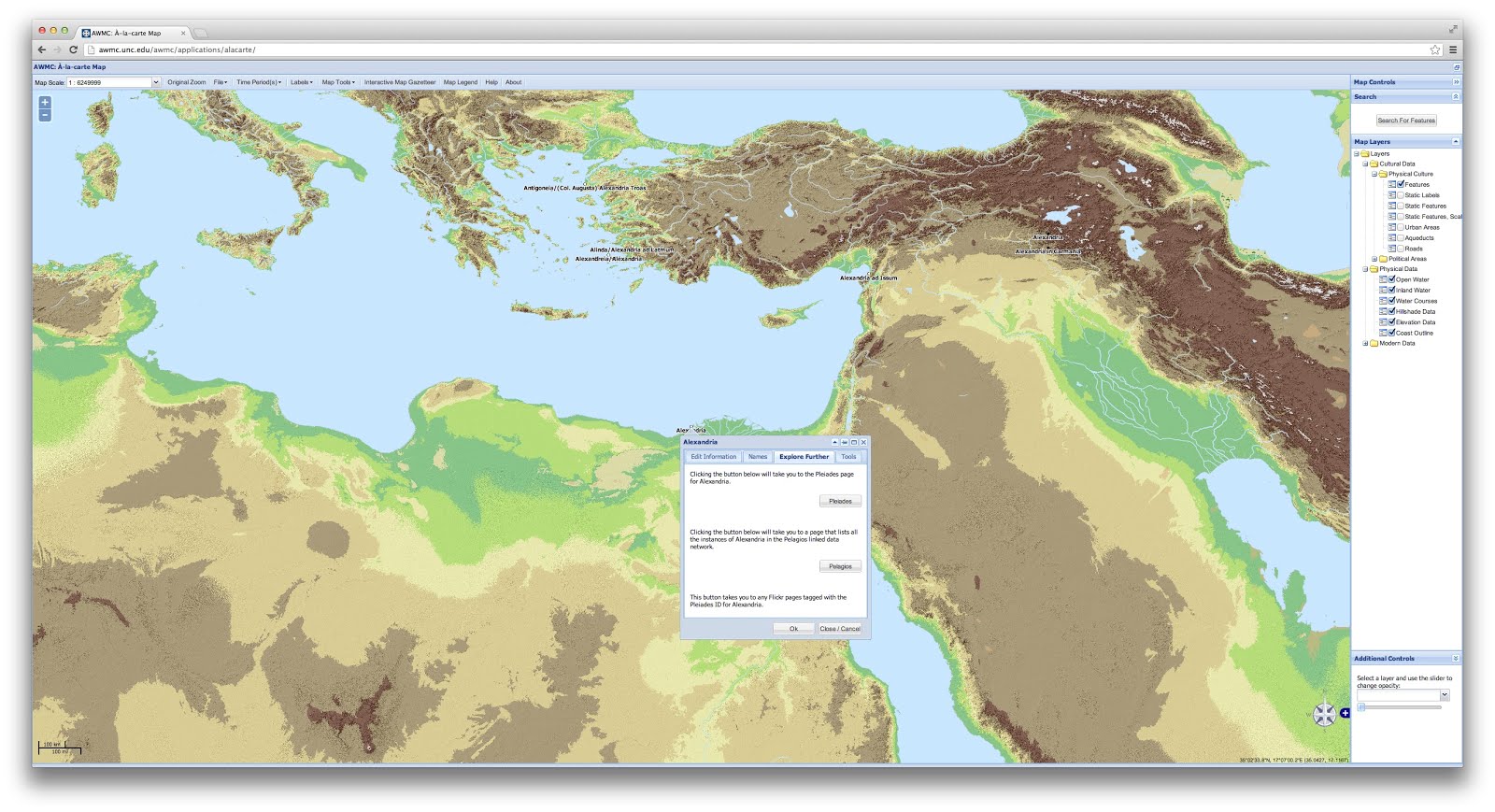
Greater difficulty was involved in matching different geographical features that are expressed in polygons or lines, as they were primarily created before the Pleiades project was conceived. Our initial attempt was to simply run a names match, but due to spelling differences, multiple results per feature, and other difficulties this proved to generate less reliable results than we wished. We next selected the relevant feature type (lakes, rivers, roads, and urban areas) from our database and then tried to assign an ID based on geography where our data corresponded with Pleiades coordinates. We discovered that Pleiades bounding boxes or representative points can overlap with other features, a problem which became readily apparent with smaller lakes and rivers that are in close proximity to other features of the same type. Ultimately we had to take our .wms file of Pleiades data points and use desktop GIS software along with the Barrington Atlas to identify and tag the relevant feature with the correct Pleiades ID. Although this process is far from complete, the AWMC API contains the matches.
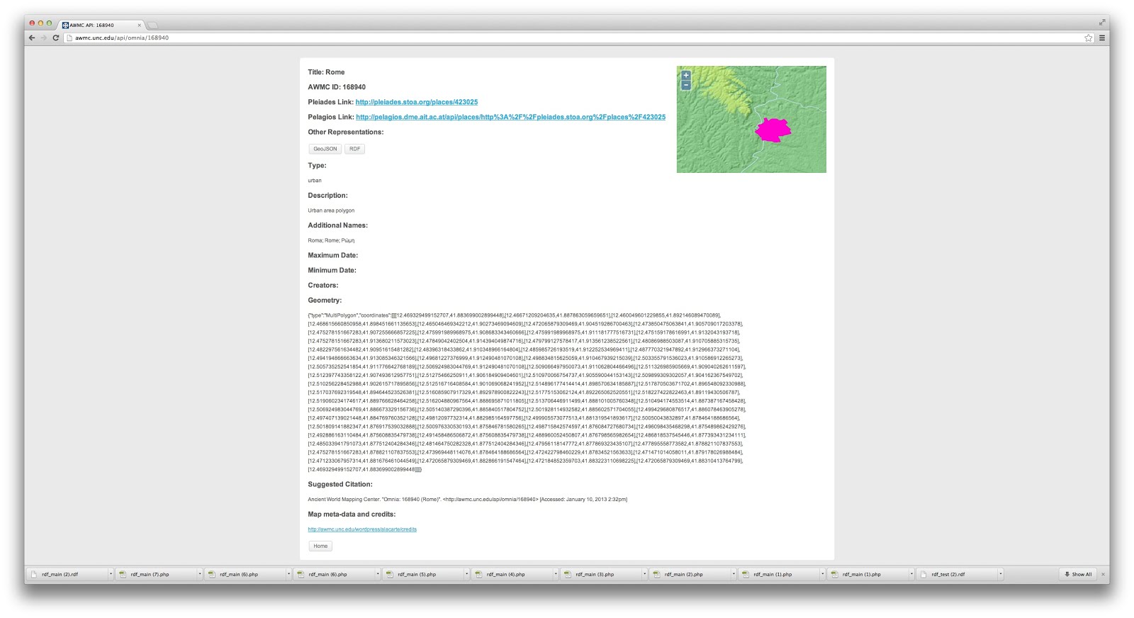
Our API was created to allow greater access to the data produced by the AWMC in a variety of different formats without the necessity of downloading a full shapefile. Our search interface allows a user to locate an object through a Pleiades ID, a unique AWMC ID, title, or type. The search then generates a list of RESTful URIs geared to a unique AWMC ID, generated through Apache mod_rewrite, PHP, and presented through DataTables. Clicking on any result will then generate a web page displaying a map locating the particular feature, relevant information about the feature in question, links to Pleiades and Pelagios, as well as links to show the feature in GeoJson (formatted for direct use in OpenLayers) or RDF representations, both of which are RESTful URIs that point to content generated on the fly by PHP scripts.
For instance, the URI for our polygon outlining the urban area of Rome at ca. 200 CE is:
with a .json representation:
and the rdf:
We are especially curious if the GeoJson representations of our data proves useful to other projects- for instance you could easily add polygons covering ancient lakes, rivers, and roads to a map keyed off of an AWMC ID directly through OpenLayers without any modification.
Since a large portion of our data is already keyed to a corresponding Pleiades ID, generating an RDF file for each entry in the preferred format for Pelagios is a relatively painless process achieved through a PHP script. At the moment we are only providing a basic abstract to describe each resource; one could certainly add more fields to these entries or change our terminology if it would be beneficial to the larger community. A sample RDF follows:
<rdf:RDF xmlns:pleiades="http://pleiades.stoa.org/places/vocab#" xmlns:rdfs="http://www.w3.org/2000/01/rdf-schema#" xmlns:rdf="http://www.w3.org/1999/02/22-rdf-syntax-ns#" xmlns:dcterms="http://purl.org/dc/terms/" xmlns:oac="http://www.openannotation.org/ns/" xml:base="http://awmc.unc.edu/api/omnia/">
<rdf:Description rdf:about="168940">
<oac:hasBody rdf:resource="http://pleiades.stoa.org/places/423025"/>
<oac:hasTarget rdf:resource="http://awmc.unc.edu/api/omnia/168940"/>
<dcterms:creator rdf:resource="http://awmc.unc.edu"/>
<dcterms:title>Rome</dcterms:title>
<dcterms:abstract>Urban area polygon</dcterms:abstract>
</rdf:Description>
</rdf:RDF>
We followed much of the same process in creating our “master” rdf file that holds all of our Pleiades aligned data. The results of this work can be seen here.
We hope the Antiquity À-la-carte application and our API together provide an impetus to begin approaching not only the cultural geography of the ancient world but the underlying physical landscape as well. Sharing and further refining the complex geometries of our resources is one of our major goals, and we are excited about the prospect of providing a simple means of adding accurate geographical information to ancient linked data projects. Combined with projects like ORBIS and other Pelagios partners, we imagine that there will be many interesting ways to integrate accurate physical geography into the linked data world.
Although we do offer all of our map files for download, AWMC is eager to participate to a community model for hosting and serving our background tiles. The Pelagios community has already embarked on such an approach and AWMC would be happy to furnish it authoritative ancient world geographical data in a similar way for other projects. We welcome feedback from the Pelagios community as to how our data may be useful or if there are suggestions for increased functionality in either our À-la-carte application or API.
AWMC is especially grateful for the help of our colleagues at Pleiades, as well as Joe Ryan, UNC ITS Humanities Research Associate.
-- Jeffrey A. Becker, Ryan Horne & Richard Talbert
CB# 8110; 5010 W. R. Davis Library
The University of North Carolina
Chapel Hill NC 27599-8110 U.S.A.


